
Marine data
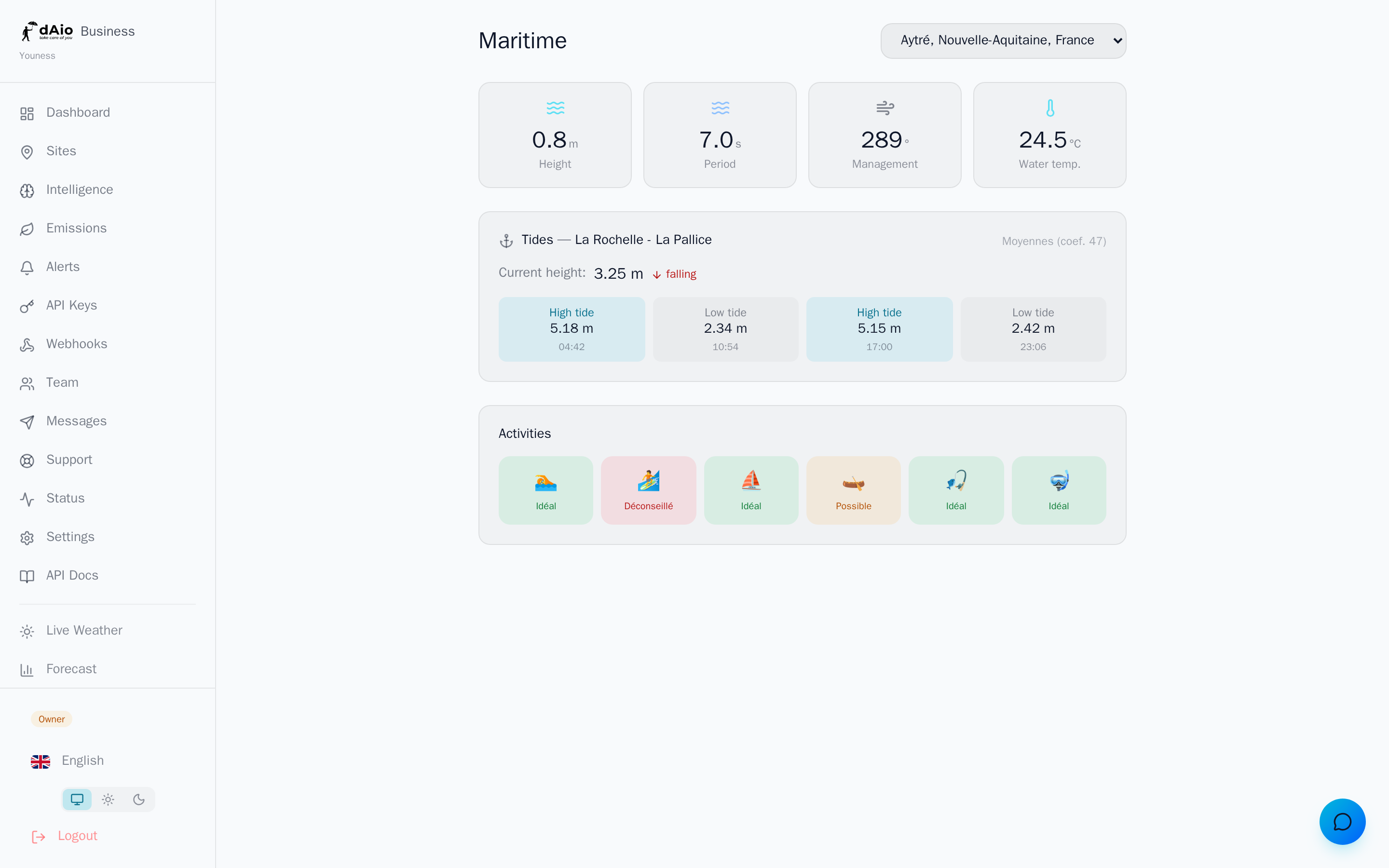
The Marine module turns a coastal site into an oceanographic observation post. Swell, tides, water temperature and activity windows: dAio aggregates this data to help you plan sea-sensitive operations — port handling, coastal construction, beachfront events, technical outings or coastal logistics.
Where conventional weather stops at the air, the Marine module goes into the water. You know not only whether it's raining, but whether the swell exceeds your safety threshold, whether the tide is uncovering your work zone, and which activities are practicable right now.
Tip: pair the Marine module with your alerts. A swell that crosses a critical threshold then becomes an actionable notification, not a figure no one looks at.
Access
The Marine module is a feature gated by your plan. Once available:
- Open the Marine tab in the Business navigation.
- Select a coastal site in the selector at the top right (if you manage several sites).
- dAio queries marine data for the site's coordinates and displays conditions in real time.
Warning: marine data is only available for coastal sites. If the selected site is inland, dAio shows a message indicating that maritime data does not apply. Check the site's coordinates if in doubt.
Swell and sea state
The main panel summarizes the sea state in four key indicators:
| Data | Unit | Description |
|---|---|---|
| Height | m | Significant wave height (average of the highest third) |
| Period | s | Time between two successive crests — a long period signals a powerful swell |
| Direction | ° | Direction the swell is coming from |
| Water temperature | °C | Sea surface temperature |
Tip: never read the height alone. A 1 m swell with a 12 s period carries far more energy than a 1 m swell at 5 s. Always combine height and period to judge practicability.
Tides
When a tide station is available near the site, dAio displays the full cycle:
- Current height — water level at the present moment, in metres.
- Trend — the sea is rising or falling, shown by an arrow and a colour.
- Tide type and coefficient — the day's forecast amplitude (when the station provides it).
- Daily extremes — times and heights of high tides (HT) and low tides (LT).
Warning: tides can uncover or submerge a work zone within a few hours. For any intervention on the foreshore (intertidal zone), plan your slots from the low-tide times shown here.
Recommended activities
From the current conditions, dAio assesses the practicability of a range of coastal activities and assigns each a visual status:
| Status | Meaning |
|---|---|
| 🟢 Favourable | Conditions suited to the activity |
| 🟠 Possible | Practicable with caution or required skill |
| 🔴 Not advised | Unfavourable or dangerous conditions |
Each activity (sailing, fishing, diving, surfing, swimming…) is shown with its emoji and colour-coded status, for an instant read of opportunity windows.
Tip: these recommendations are a decision aid, not an authorisation. They replace neither local regulations, nor a professional's judgement, nor the official bulletins of maritime authorities.
Who is it for?
The Marine module is aimed at any organisation whose activity depends on the sea or the coast:
- Ports and handling — berthing windows, safety of quayside operations.
- Construction and coastal works — foreshore interventions, dikes, maritime structures.
- Beachfront events — public safety, bathing, water-based activities.
- Water sports and tourism — planning outings according to sea state.
- Logistics and fishing — choosing slots based on swell and tide.
Best practices
- Link each coastal site to the right location: the accuracy of the coordinates directly determines the reliability of tides and swell.
- Combine swell and period rather than judging on wave height alone.
- Plan foreshore work from the low-tide times, not the instantaneous trend.
- Set up alerts on your critical thresholds so you don't have to monitor the dashboard continuously.
- Always cross-check with the official bulletins of maritime authorities for safety-critical decisions.
Tip: combine the Marine module with the site's weather intelligence for a complete picture — air and water, in the same place, for grounded operational decisions.